This is an addition to my most recent post, where I'll put some extra details!
1) Present day locations of some old stations:
The Route of the line was a pretty interesting one. It passed through famous landmarks, moved through cut up mountains, and over a former marshland! In this section, we'll find the location of two of these stations, Bori Bunder, and the old Byculla.
a) Bori Bunder
The route began at Bori Bunder station. You would want to know where it once stood.
 |
| The Bori Bunder station |
Thankfully, cartographers of the past era made detailed maps, interpolating which with present day maps, helps us trace out the older structures. And I did just that.
 |
| An 1855 Map of Bombay |
And this I put behind a screenshot from Google Earth. I carefully aligned as many roads, buildings, and even narrow lanes as I could, and finally ended up with this-
 |
| 1855 v/s now (credit for satellite map- Google Earth) |
It might look disgusting at first, because within the span of 170 yrs, several changes have been made. But yet, you might want to look at the upper right part. Doesn't it look like a wonderful match? At certain places, there's clutter, but at others, all lines perfectly.
Well, this is how you can pin point ancient landmarks to a high precision. If you observe carefully, you may spot CSMT as that portion with a large railway yard. We're lucky, as Bori Bunder station has been mentioned on the 1855 map. Interpolating, we find that Bori Bunder was situated just a bit north of today's CSMT. I've put the interpolation on Google Earth.
 |
| The White area represents the station complex. The white line depicts the railway. Credit: Google Earth |
b) Byculla
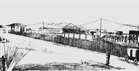
Byculla was among the more interesting ones. It was quite a humble station, with just two platforms, and a road over bridge at its northern end. In the background was the Byculla Mankeshwar Temple, one that manages to appear in most of the station's old pictures.
 |
| The old Byculla station. Note the Temple in the Background, along with the bridge! |
The Old station was situated around 550 m south of the present station. The site can be located easily using the temple as a guide. Consulting the old images carefully allows us to estimate the position and structure better. (Again credit to Google Earth)
 |
| An Approximate Interpolation. The Platforms are labelled Yellow, the bridge Grey, while the Temple is marked Red |
And here's a bigger picture for better understanding. Spot the present Byculla station with its red roof-
 |
| The bigger picture (Credit: Google Earth) |
More to be added soon!


No comments:
Post a Comment